Showing 71 items matching hill view station
-
 Federation University Historical Collection
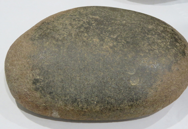
Stone tools, Aboriginal stone axe blank and grinding stone
... hill view station... at Hill View Station. The tertiary rock is quartzite... axe blank of Western Australian origin, found at Hill View ...(.1) Stone axe blank of Western Australian origin, found at Hill View Station. The tertiary rock is quartzite, a metamorphosed igneous rock, and has a red, or iron oxide colour. (.2) An oval grinding stone of Western Australian origin, found at Hill View Station. The rock is metamorphosed igneous rock, potentially greenstone. One surface has evidence of a rough depression, possibly made in preparation for sharpening of a tool or similar.aboriginal, stone, tool, archaeology, stone tools, western australia, hill view station, quartzite, grinding stone, grind stone, greenstone, stone axe, stone axe blank, blank -
 Eltham District Historical Society Inc
Folder, George Fletcher, 1878
... on the View Hill station, Yarra Flats, and stayed there for four years... to Victoria, was employed on the View Hill station, Yarra Flats ...Folder of information on George Fletcher, Councillor, Steels Creek, 1878. Fletcher, George, Yarra Flats was born in Herefordshire, England, in 1830, and came to Australia, landing in Adelaide, S.A. in 1851. A year afterwards he came to Victoria, but after visiting the Bendigo goldfields and other places returned to Adelaide. In 1859, he again came to Victoria, was employed on the View Hill station, Yarra Flats, and stayed there for four years. In 1867 he selected 80 acres under the Land Act of 1865, and afterwards an additional 320 acres on Steel's Creek, where he now carries on faming and dairying. During htis time Mr. Fletcher has been a member of the board of advice for the east riding of the shire of Eltham, and about twelve years ago he was elected a member of the shire council, and continued so for a term. Mr Fletcher was married in 1859, and has a family of four sons and four daughters. Fom "Victoria and its Metropolis: Past and Present" written in 1888 by Alexander Sutherland. Chapter 19, "The Upper Yarra District" pages [402] - 415. Includes descriptions of some townships and short biographies of local residents. Page 405 george fletcher, steels creek -
 The Beechworth Burke Museum
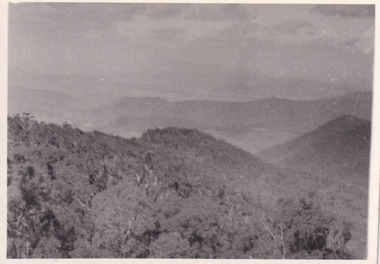
Photograph, 1944
Taken in 1944, the photograph depicts the view of surrounding hills from Mt. Stanley. A secret experimental micro-wave radio station was established and tested at this site by the Army Signal Detachment Unit during World War II. It was part of an experimental Ultra High Frequency (UHF) link between Melbourne and Sydney. At the time, it was highly classified. It intended to enquire into the hitherto unexplored transmission of micro-waves; that is, a radio signal which could only be transmitted by line of sight, and thus required hill-top to hill-top location.The photograph is historically significant as it pertains to World War II; the largest global conflict in history. This significance is enhanced by Australia's prominent involvement in campaigns across the Pacific, particularly on land in New Guinea and across the Huon Peninsula. It was also the first time that the Australian mainland came under direct attack by the Axis, with Japanese forces targeting north-west Australia and Sydney Harbour. These battles became Australia's largest and most complex offensives during the war. The record is also historically significant as it relates to the Royal Australian Corps of Signals, or "RA Sigs". This significance is strengthened by Australia's unique distinction of having the first established signal unit under the British Empire. This unit provides electronic warfare. They enable commanders to implement highly dynamic battle control against opposing forces by using a number of methods including radio, fibre optic, micro-wave, information systems and satellite links. The record has strong research potential. This is due to the ongoing scholarly and public interest in war, military history, the ANZAC legend, and the ongoing existence of the RA Sigs. The historic context of this record can provide insight into Australia's history, military, technological innovation and advancements, as well as national economic, defence and foreign policies after 1945.Black and white rectangular photograph printed on matte photographic paper.Reverse: BMM5095.2 / 32 /military album, army album, wwii, world war ii, army signal detachment unit, royal australian signal army corps, war, beechworth, victoria, mt. stanley -
 The Beechworth Burke Museum
Photograph, 1944
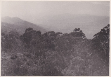
Taken in 1944, the photograph depicts the view from Mt. Stanley. A secret experimental micro-wave radio station was established and tested at this site by the Army Signal Detachment Unit during World War II. It was part of an experimental Ultra High Frequency (UHF) link between Melbourne and Sydney. At the time, it was highly classified. It intended to enquire into the hitherto unexplored transmission of micro-waves; that is, a radio signal which could only be transmitted by line of sight, and thus required hill-top to hill-top location.The photograph is historically significant as it pertains to World War II; the largest global conflict in history. This significance is enhanced by Australia's prominent involvement in campaigns across the Pacific, particularly on land in New Guinea and across the Huon Peninsula. It was also the first time that the Australian mainland came under direct attack by the Axis, with Japanese forces targeting north-west Australia and Sydney Harbour. These battles became Australia's largest and most complex offensives during the war. The record is also historically significant as it relates to the Royal Australian Corps of Signals, or "RA Sigs". This significance is strengthened by Australia's unique distinction of having the first established signal unit under the British Empire. This unit provides electronic warfare. They enable commanders to implement highly dynamic battle control against opposing forces by using a number of methods including radio, fibre optic, micro-wave, information systems and satellite links. The record has strong research potential. This is due to the ongoing scholarly and public interest in war, military history, the ANZAC legend, and the ongoing existence of the RA Sigs. The historic context of this record can provide insight into Australia's history, military, technological innovation and advancements, as well as national economic, defence and foreign policies after 1945.Black and white rectangular photograph printed on matte photographic paper.Reverse: BMM5095.3 / 32 /military album, army album, beechworth, victoria, mt. stanley, australian army, wwii, world war ii, royal australian signal corps, army signal detachment unit -
 The Beechworth Burke Museum
Photograph, 1944
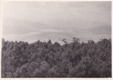
Taken in 1944, the photograph depicts the view from Mt. Stanley. A secret experimental micro-wave radio station was established and tested at this site by the Army Signal Detachment Unit during World War II. It was part of an experimental Ultra High Frequency (UHF) link between Melbourne and Sydney. At the time, it was highly classified. It intended to enquire into the hitherto unexplored transmission of micro-waves; that is, a radio signal which could only be transmitted by line of sight, and thus required hill-top to hill-top location.The photograph is historically significant as it pertains to World War II; the largest global conflict in history. This significance is enhanced by Australia's prominent involvement in campaigns across the Pacific, particularly on land in New Guinea and across the Huon Peninsula. It was also the first time that the Australian mainland came under direct attack by the Axis, with Japanese forces targeting north-west Australia and Sydney Harbour. These battles became Australia's largest and most complex offensives during the war. The record is also historically significant as it relates to the Royal Australian Corps of Signals, or "RA Sigs". This significance is strengthened by Australia's unique distinction of having the first established signal unit under the British Empire. This unit provides electronic warfare. They enable commanders to implement highly dynamic battle control against opposing forces by using a number of methods including radio, fibre optic, micro-wave, information systems and satellite links. The record has strong research potential. This is due to the ongoing scholarly and public interest in war, military history, the ANZAC legend, and the continuing existence of the RA Sigs. The historic context of this record can provide insight into Australia's history, military, technological innovation and advancements, as well as national economic, defence and foreign policies after 1945.Black and white rectangular photograph printed on matte photographic paper.Reverse: BMM5095.4 / 32 /military album, army album, wwii, world war ii, mt stanley, beechworth, victoria, melbourne, sydney, royal australian corps of signals, army signal detachment unit, military, war -
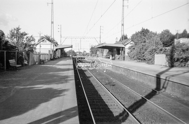
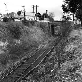 Greensborough Historical Society
Photograph - Digital Image, Single train track in the cutting at Greensborough 1970s, 1970s
Photograph of the single track approaching Greensborough Railway Station in the 1970s. This view is from behind the station master's house. On the hill to the left is Connie Burkett's hair salon in the Valley Buildings.Digital copy of black and white photograph.greensborough railway station, trains, main street greensborough, connie burkett -
 Federation University Historical Collection
Photograph - Photograph - Black and White, Photographs of Ballarat Buildings by Geoff Biddington, 1967
Geoff Biddington took numerous photos around Ballarat and District. He was an active member of the Ballarat Branch of the National Trust. 48 black and white photographs of Ballarat buildings. 1. National Bank, Buninyong 2. Gas Light Standard, Geelong Road, Mount Clear 3. Water Hydrant 4. Former Police Station, Camp Street 5. Cast Iron Drinking Fountain, Eureka Stockade 6. Buninyong Gold Discovery Monument 7. Ballarat Old Cemetery Gates 8. Ballarat East Post office 9. Carriers Arms, Doveton Street North 10. North Star Hotel, Lydiard Street North 11.Lake View Hotel 12. Former Ballarat Gaol, Gate Two 13. Beaufort House 14. Smythesdale Post Office 15. Ballan Timber Building 16. National Mutual Building, Sturt Street 17. Craig's Hotel Doors 18. Her Majesty's Theatre Stage 19 & 20. Ballarat Botanical Gardens Statuary House 21 & 22. Stonemason at work 23. Methodist Church School (1867) Humffray Street 24 & 25. Methodist Church, Brown Hill 26. Queen St Statue,Sturt Street 27-29. Sturt Street Fountain 30. Moore Statue, Sturt Street 31. Hede Statue, Sturt Street 32. George V Statue (Victor Greenhalgh), Sturt Street 33-35. Peter Lalor Statue, Sturt Street 36. Art Deco Statue, Sturt Street 37. Beaufort Bandstand 38. Ranger Barracks, Curtis Street, Ballarat 39. Smeaton Mill and Bridge 40. Hepburn Graveyard, Smeaton 41-45 - Ballarat Tram Ride (possibly last) 46-48. Taking up the Ballarat Tram Tracks, 1967 .49. Melbourne House, Sebastopolgeoff biddington, biddington, buninyong, mount clear, police, gold, cemetery, hotels, ballarat gaol, beaufort house, smythesdale, ballan, theatre, statue, statues, statuary, peter lalor, ranger barracks, smeaton mill, smeaton bridge, hepburn, tram, sebastopol, craig's, her majesty's theatre, smeaton, hepburn graveyard, gold monument, queen victoria statue, ballarat, foodland, ballarat, ballarat buildings, former eagle hotel, former ballarat police station, gold discovery, craig's hotel, buninyong gold discovery obelisk -
 Federation University Historical Collection
Photograph, Marilyn Jeffs, Hotels of Ballarat, 2019
Numerous photographs take by Marilyn Jeffs for use on the Ballarat and District Industrial Heritage Wikihotels, ballarat, royal mail hotel, peter lalor hotel, the george hotel, x on albert hotel, cattleyards inn, market hotel, bunch of grapes hotel, argyle hotel, atlantic hotel, ballarat hotel, black hill hotel, blue bell hotel, bluebell hotel, brown hill hotel, canberra hotel, carboni, carboni's italian kitchen, eureka stockade hotel, carriers arms hotel, eastern station hotel, centenary hotel, craig's hotel, eastern railway hotel, freight bar, athletic club hotel, grapes hotel, munster arms hotel, golden city hotel, golf house hotel, irish murphy's, camp hotel, lake view hotel, la porchetta, southern cross hotel, the mallow hotel, meaghers hotel, millers arms, miners tavern hotel, miner's tavern hotel, provincial hotel, north britain hotel, north star hotel, oscar's hotel, criterian hotel, park hotel, prince regent house, prince regent hotel, sport globe, sporting globe, jacksons hotel, railway hotel, pwtn, pater lalor hotel, royal highlander hotel, queen's head hotel, red lion hotel, robin hood hotel, military arms hotel, royal oak hotel, western hotel, imperial hotel, unicorn hotel, union hotel -
 Kiewa Valley Historical Society
Book - Non Fiction History, The Kiewa Story, circa 1993
This book provides in chronological order the development of the Kiewa Hydro-electricity scheme from the first concept (1911) to final construction work (1961). It covers the first attempt to utilise the power of the Victorian Alps water system. It started from a private syndicate and developed to the current State Electricity Commission of Victoria. The incentive for the Hydro scheme was to make money and not as an alternative to the carbon producing coal fired power plants. These coal fired power plants were increasing in numbers to service an ever increasing demand made by population expansion, especially in cities and large rural settlements. This demand spiraled up after World War II when there was a tremendous spike in immigration numbers due to refugees and displaced persons in Europe. The ability to utilise the untapped water provided by the winter snow fields, for a higher yield in electricity, was a powerful incentive to overcome the physical hardships in this remote Alpine region. Future power requirements may initiate the re-installation of the other two power stations(Pretty Valley and Big Hill) covered in original Scheme. This publication not only covers the development of the Kiewa Valley region with respect to population (within a socio-economical framework) but also the subtle but yet strong physical changes of a relatively pristine alpine region. The demands that an ever growing regional population places on the environment is clearly documented in print and black and white photographs. The working and living conditions of those who constructed and gave life to this hydro scheme is well documented in this book. It may be viewed as spartan now but was relevantly good at that moment in time, especially for those workers fleeing a devastated European environment. The successful planning and consideration to minimising any intrusion upon the natural alpine forests and high plains can viewed as an example (compared to the Tasmanian Hydro schemes) of how future hydro schemes (an inevitable requirement) will proceed. Most rural towns (in the early 1900s) were built by unencumbered rural based citizens, with the exception of Mount Beauty and Falls Creek. These two settlements were brought into life by a State (Victorian) Authority for a specific function and program. They were a gated community, that is, only open to construction workers involved with the hydro scheme. All facilities within these communities were provided by the State Electricity Commission of Victoria. The impact on the social, financial and individual independency of the community, by the transition from the S.E.C .environment to one of local government (Shire of Bright), had in some cases a severe impact.This hard covered book has a green cover with pictures on the front and back covers. The front cover has a coloured picture of a snow covered Mount Bogong taken from the opposite mountain range. The valley between both ranges has a whisk of mist over it. At the bottom of this picture are three black and white photographs covering the construction of the Kiewa Hydro - Electricity Scheme. On the back cover is a photograph, (black and white) detailing the Bogong village and Junction dam containing lake Guy. The inside front cover is a black and white photograph which details the construction of the West Kiewa tailrace tunnel during April 1951. The inside back cover is a black and white photograph of the concrete pour at the Clover Dam circa 1952. All photographs and sketches are in black and white. The pages are approximately 160 g/m2 and those which have photographs are on gloss paper.Book spine: "The Kiewa Story Graham Napier Geoff Easdown" alongside this is a white framed circle with white spokes radiating out and underneath in white lettering SECkiewa valley, hydro scheme, victorian alpine region, electricity generators, graham napier, geoff easdown -
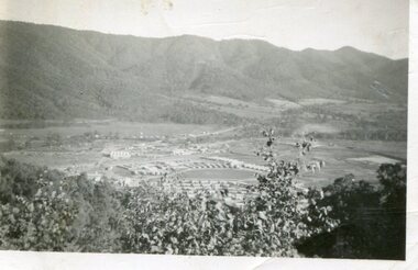
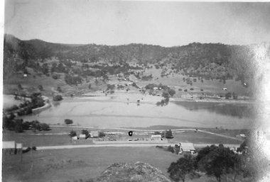
 Kiewa Valley Historical Society
Photograph of Kiewa Valley Panorama, Kiewa Valley from No. 5 Road, Before 1945
In 1943 a camp for workmen was erected and a commencement made with the erection of plant storage and workshop buildings in the new township of Mt. Beauty. The photograph was probably taken after the completion of these buildings. There is no sign of construction of the town itself. In the latter part of 1945 work was commenced on the Mt. Beauty township area with a medical centre, general trading store and some houses under construction. The No. 5 Road, from where the photograph was taken, is the road to West Kiewa Power Station and Big Hill Scenic Lookout.Is an excellent view of the Kiewa Valley before there was little work undertaken to establish the town of Mt. Beauty. Farming was well established with the evidence of huge areas of cleared land. The junction of the East and West Kiewa Rivers can be clearly seen. The first Workmen's camp is near the river and some workshop buildings can also be seen. Black and white photograph of the Kiewa Valley, looking North.Handwritten on the back of photograph "Kiewa Valley from No. 5 Road".kiewa valley, camp, buildings, mt. beauty -
 Kiewa Valley Historical Society
Photograph - Mount Beauty from Bogong Hill, 1950
The new State Electricity Commission construction camp at the head of the Kiewa Valley was for workmen on the second power station in the project expected to be the most modern and best equipped in Australia… In contrast to the early Kiewa days of horses and canvas tents, the new camp, with its modern amenities, compared favourably with any country town. Administration of the Kiewa Scheme was moved from Tawonga to Mount Beauty in 1946. The first house in Mount Beauty, in Hollonds Street, was occupied by the co-op store manager from November 1946. The new Mess Hall at Mt Beauty was opened with much ceremony in early November 1946. The houses up to Nelse street were erected from 1946 onward and then the township was extended beyond Nelse Street in 1950. The workmen's camp was enlarged in 1950 to the extent of providing accommodation for a total of 1,200.Shows early construction of the town of Mt. Beauty surrounded by farmland taken in 1950 during the early stages of construction of the Kiewa Hydro electric SystemBlack and white photograph - aerial view of Mt Beauty taken from Bogong Hill. Photograph framed by 6mm white boarder.Handwritten on back of photograph in black ink - Mt Beauty from Bogong Hill 1950 Printed on rear Volox 2428mt beauty, bogong hill, secv -
 Kiewa Valley Historical Society
18 small black and white photographs of the Bogong High Plains, 1948
These photos of the Bogong High Plains were all taken by Ronald George Thorn who was a cadet engineer with the State Electricity Commission. He worked on the Kiewa scheme from 1948 to 1950 doing overhead line construction and maintenance plus electrical design and drawing work. They are from his personal collection and a record of his time in the Kiewa area.Pictorial history of personal involvement in the the early days of the Kiewa Scheme.18 small black and white photographs all taken on the Bogong High Plains.Photo 1 Wallace's Hut. Photo 2 Ruined Castle - Looking towards Pretty Valley December 1948. Photo 3 Ruined Castle - Looking towards Pretty Valley December 1948. Photo 4 Ruined Castle - Looking Down Valley December 1948. Photo 5 - Mt. McKay from Ruined Castle October 1948. Photo 6 View from Rocky Valley Camp October 1948. Photo 7 Mt. Feather Top from Ruined Castle October 1948. Photo 8 View from Ruined Castle looking downwards towards Beauty October 1948. Photo 9 Rocky River from gauging station October 1948. Photo 10 Rocky Valley River from main road October 1948. Photo 11 View along little Arthur Fire Track October 1948. Photo 12 View along main road. Looking towards Beauty Valley October 1948. Photo 13 View from Little Arthur Fire Track October 1948. Photo 14 Frying Pan Spur from Rocky Valley Road October 1948. Photo 15 Mt. Bogong from Big Hill Fire Track October 1948. Photo 16 View from Big Hill Fire Track October 1948. Photo 17 Mt. Feathertop from Ruined Castle October 1948. Photo 18 Mt. Fainter from Ruined Castle October 1948. (All of the above is hand written on the back of photos in ink). bogong high plains; r g thorn; secv; kiewa hydro electric scheme; pictorial history -
 Kiewa Valley Historical Society
Photograph - Folder of Photographs – Photocopied set of black and white photographs (pages 39 - 48) from the display folder put together by KVHS to document life on the Kiewa Valley Hydro-electric Scheme
Although the Kiewa Hydro-Electric Scheme was first proposed in 1911, construction did not commence until 1938. As part of the push to cut electricity costs and diversify supply, the Victorian Government (circa 1930) initiated the conversion from primarily brown coal supply to hydro – electricity. Field investigations during the 1940’s resulted in a new proposal for a scheme that had more than double the capacity of the 1938 scheme. The Kiewa Hydroelectric Scheme became the largest scheme of its kind in the State Of Victoria and the second largest scheme in Australia. The number of personnel involved in the planning and construction of the scheme increased dramatically. During the late 1940’s, most activity centered around the construction of the West Kiewa Power Station, Rocky Valley Reservoir, McKay Creek Power Station and the Bogong Creek Aqueduct.A common thread across all the larger hydro scheme constructions was the need for workers, both qualified and unqualified who came from around the world seeking a new life for themselves and their families. New accommodation and facilities were required for the army of workers engaged in construction in often remote and wild areas. The SEC had a high demand for timber, and set up the first of a number of sawmills at Bogong Creek in 1939 and set up the first hardwood logging in the headwaters of the Kiewa River. These new ‘towns’ such as Mt Beauty and Bogong, survived, serving the needs of operational personnel and their families, and expanding with growth of new industries. Mount Beauty, and to a lesser extent Bogong, are among these places. Large A3 size spiral bound display folder containing photocopied black and white photographs of various aspects of the early days of the Kiewa Valley Hydro-electric scheme including equipment, various work sites and photographs of workers and their families. 1-Breakdown in Circuit Breaker (Isolating Contacts) 2-Big Hill Bench- Site of No 5 Devlopment 3-No 1 Power Station 4-No 1 Pipeline, Anchor No 8 5-Push Dozing-RD8 Tractor 6- Tractor and driver at work 7- Workmen in unnamed tunnel 8- Front page of Journal of SECV Vol 15. Photograph of No 1 pipeline viewed from McKay Portal 9-Rocky Valley Dam Core Wall 10-Workmen working inside tunnel loading rocks into a rail truck. 1-Breakdown in (generator) Circuit Breaker (Isolating Contacts) Handwritten underneath (This is not a picture of any part of a generator. It is a circuit breaker Signed Ron White Ron was the Principal Hydro Engineer of the SEC Kiewa Scheme Page number 39 2-Big Hill Bench – Site of No. 5 Development (abandoned) Page number 40 3-No 1 Power Station Page number 41 4-No. 1 Pipeline, Anchor No. 8 Page number 42 5-Push Dozing – RD8 Tractor, 12 cubic yard Carryall and FD Cletrac Tractor Page number 43 6-No marking Page number 44 7-No marking Page number 45 8-Journal of State Electricity Commission of Victoria SEC Vol 15 No… April-May, 19… No 1 Pipeline-A view from McKay Portal G Hempenstall and D Sutton stiffening pipe section for transport during construction (….indicates missing text) Page Number 46 9-Rocky Valley Dam Core Wall Page number 47 10-No markings Page number 48 secv; kiewa hydro electric scheme; construction area; power stations; reservoirs; aqueduct; mt beauty; bogong -
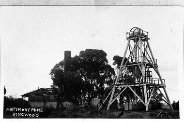 Ringwood and District Historical Society
Photograph, View of the Ringwood Antimony Mine, buildings and headframe. C1900, c. 1900
The Antimony mine, set on top of a hill, was originally the centre for Ringwood development. The centre was relocated to the west around Ringwood station when the railway was built.View of the Ringwood Antimony Mine, buildings and headframe. A chimney from a smelter can be seen on the LHS. -
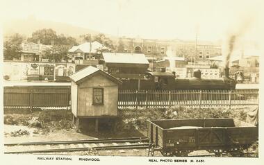 Ringwood and District Historical Society
Photograph, Ringwood Railway Station, including view of platform advertising, Main Street shops, and Loughnan's Hill. c.1925
Inscription below photograph reads, "Railway Station, Ringwood. Real photo series M.2451." "c.1925". -
 Eltham District Historical Society Inc
Photograph, Looking west at intersection of Mountain View Road with Sherbourne Road, Briar Hill, c.1985, 1985c
[Note: dated based on negatives 01791 (20 Jan 1986) as service station (in other frames on roll of film) and pricing for fuel very similar period; possibly late 1985]Roll of 35mm colour negative film, 7 stripsKodak CL 200 5093mountain view road, briar hill, sherbourne road -
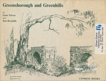 Eltham District Historical Society Inc
Book, Irene Turvey et al, Greensborough and Greenhills / words by Irene Turvey ; Drawings by Ron Reynolds, 1973
Pen and ink sketches accompanied by appropriate text in double page spreads. Contents cover : Blue stone bridge, Introduction, House cnr Church and Hailes Street, House - 25 Hailes Street, Yandell Reserve, Greensborough Hotel, Lobb's Kiosk, House - 49 Grimshaw Street, View of Greensborough (from Delphin Crescent), Railway Station, Old Barn (near Greensborough Railway Station), Partington's Flat and River Valley, Rand Street Bridge, Lower Main Street, Greenbriar Nursery, Hitching rail, Ashmead - Dr Cordner's Home, Greensborough Primary School, House - cnr St Helena and Diamond Creek Raods, Sondermeyer's Hill, Methodist Church, Football Pavilion, Cemetery, St Katherine's Church, St. Helena, Civic Centre, Briar Hill Timber Mill, 24 River Street, Kelly's Garden Supplies, 158 Main Street, Old Swimming pool, 105 Main Street.Hardback; 62 p. : ill., map ; 19 x 25 cm.ISBN 0909807108 Signed by author and illustrator Two copiesgreenhills, greensborough -
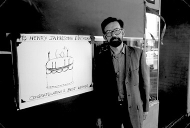 Surrey Hills Historical Society Collection
Photograph, Exterior of Henry Jamieson Radio Business, 145 Union Road, Surrey Hills
Henry was born in View Street and then Newton Street. He went to Box Hill Grammar School. Before his marriage he lived in Mont Albert Road. Adrian Knowles had started a radio shop at 145 Union Road in the 1940s and Henry joined him later continuing the business in his own name. Henry always had an interest in music and became involved in getting the radio station 3MBS established in Kew. For some years Henry and a co-producer presented a prime time Saturday evening programme and also an early morning one.A black and white photograph of a man with dark hair, wearing dark rimmed glasses and a suit coat, is standing beside a white board someone has decorated for Henry Jamieson's 60th birthday.(mr) henry jamieson, view street, newton street, box hill grammar school, mont albert road, union road, surrey hills, 3mbs, adrian knowles -
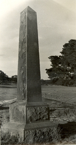
Clunes Museum
Photograph - PHOTOGRAPH CLUNES 1860, CIRCA 1860
COLLAGE - CLUNES IN THE 1860's SIX REPRODUCED PHOTOGRAPHS MOUNTED IN WOODEN FRAME WITH BOLD EMBOSSED TRIM. CRITERION QUARTZ MINING COMPANY, PORT PHILIP & COLONIAL GOLD MINING COMPANY, VICTORIA QUARTZ MINING COMPANY. VIEW OF CAMP HILL , VIEW OF PORT PHILIP MINE SIGHT, VIEW OF THE LEVEL SIGHT OF BATTERY SEEN ON THE SIGHT ALONG STATION FLAT ROAD.local history, photographs, mining and township -
 Bendigo Art Gallery
Photograph - Work on paper, Nicholas CAIRE, View Taken From St. Paul's Tower, Sandhurst, 1875
Inscribed on original mountcard, l.l., gold letterpress, "N.J. CAIRE"bendigo, sandhurst, train station, quarry hill, photograph, st. paul, work on paper -
 El Dorado Museum Association Inc.
Photograph (item) - Digital Image
Cocks Pioneer Ponds from Monument Hill. Cocks Pioneer Electric Gold & Tin Mine Company was formed in 1899. The company's first power station, located at the eastern end of the valley began operating with its 340 Kilowatt steam-powered generator. By 1909, from 2,500,000 cubic yards worked, reported recovery was 17,284 ounces of gold and 224 tons of tin ore. By 1909, Cocks Pioneer’s power plant had become inadequate and uneconomical. The barge was floated downstream about a mile, but lost time caused the operations to cease. Following testing, a new mine was established by diverting Reid's Creek at a cost of £25,000. Settling dams were built, one of which held 1,935,900 cubic feet. Sold earth banks, built against a wall of stringy bark saplings constructed and laced with vertical props, were built. In 1914, the company was reformed as Cock’s Pioneer Gold and Tin Mines NL, another power station was constructed at the western end of the township, near the junction of Clear and Reid's Creeks. From 6,800,000 cubic yards of material processed, the returns were 64,397 ounces of gold and 855 ton of tin. Cocks Pioneer mine then moved the barge downs stream and continued sluicing. In 1929 Cocks Pioneer Electric Gold and Tin Mining Company ceased operations due to a drop in values. Cock’s Pioneer Gold and Tin Mines NL carried on large-scale hydraulic sluicing operations until 1941. mining, gold, tin, hydraulic, sluicing, gold mining, tin mining, monument hill, cocks pioneer, el dorado, eldorado -
 Stawell Historical Society Inc
Photograph, Panoramic view from Big Hill with the Town Hall and Coffee Palace formerly Castlemaine Hotel & aso the Train at Station 1880
Stawell Township from Big Hill 1880 Town Hall and Coffee Palace formerly Castlemaine Hotel, can be seen. Train at Station.stawell -
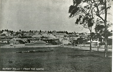 Surrey Hills Historical Society Collection
Photograph, Surrey Hills from north of Montrose Street 1907-1911
In the foreground is Dr Blakie's first surgery, later the Police Station, then a Service station. Behind and to the left are the two railway station buildings. On the horizon and in front of the pine trees is 'Montalto', home of the Hansen family, later Dr Box (demolished). Two storey terrace of shops in front of this is Hansen's Terrace. In centre, note smoke from steam train. On corner of Guildford Rd is a Gas Lamp. The first trees have been planted in Union Road and are protected with stout wood surround.Black and white photograph of a view of Surrey Hills. Written on the bottom left hand side "SURREY HILLS - FROM THE NORTH". In the foreground are two trees on the right hand side before a view leading up the hill. dr blakie, police station, hansen terrace, dr box, montalto, guildford rd, gas lamp, union road -
![Scene near Corranderrk Station / [by] Nicholas Caire, circa 1876](https://victoriancollections.net.au/media/collectors/550653872162f11fb04854aa/items/57774ae0d0cdd10a5c12f2d7/item-media/57774b61d0cdd10a5c132dac/item-fit-380x285.jpg) Kew Historical Society Inc
Kew Historical Society IncPhotograph, Anglo-Australasian Photographic Company, Scene near Corranderrk Station, c. 1876
Nicholas Caire was born on Guernsey in the Channel Islands in 1837. He arrived in Adelaide with his parents in about 1860. In 1867, following photographic journeys in Gippsland, he opened a studio in Adelaide. From 1870 to 1876 he lived and worked in Talbot in Central Victoria. In 1876 he purchased T. F. Chuck's studios in the Royal Arcade Melbourne. In 1885, following the introduction of dry plate photography, he began a series of landscape series, which were commercially successful. As a photographer, he travelled extensively through Victoria, photographing places few of his contemporaries had previously seen. He died in 1918. Reference: Jack Cato, 'Caire, Nicholas John (1837–1918)', Australian Dictionary of Biography. The 1860s marked the beginning of the era of reserves and missions. Six Aboriginal reserves were established during the 1860s. These were under the control of the Board for the Protection of Aborigines. Four were Christian missions receiving government aid. These were Lake Tyers (Anglican) and Ramahyuck (Presbyterian/Moravian) in eastern Victoria for the Gunai/Kurnai clans; Ebenezer (Moravian) in north-west Victoria for the clans of the Wimmera and Lower Murray; and Lake Condah (Anglican) in south-west Victoria. The other two were secular government controlled reserves: Framlingham which, like Lake Condah, was established for the Mara-speaking Gunditjmara and Kirrae-wurrung people of south-west Victoria; and Coranderrk, located about 60 kilometres north-east of Melbourne, for the Kulin clans of central Victoria. In 1863, after a period of devastation to the Kulin people, Coranderrk was established at the junction of the Yarra River and Badger Creek. Reference: http://coranderrk.com/, accessed 24 December 2016An original, rare photograph from the series 'Views of Victoria: General Series' by the photographer, Nicholas Caire (1837-1918). The series of 60 photographs that comprise the series was issued c. 1876 and reinforced a neo-Romantic view of the Australian landscape to which a growing nationalist movement would respond. Nicholas Caire was active as a photographer in Australia from 1858 until his death in 1918. His vision of the Australian bush and pioneer life had a counterpart in the works of Henry Lawson and other nationalist poets, authors and painters.Albumen silver photograph mounted on boardprinted in ink on support l.c.: SCENE NEAR "CORRANDERRK" STATION. / COPYRIGHT REGISTERED. printed in ink on support reverse c.: VIEWS OF VICTORIA. / (GENERAL SERIES.) / No. 9. / SCENE NEAR "CORRANDERRK" STATION. / This scene was taken from the hill near Rourke's Bridge, on the Healesville Road, and displays in the foreground / the River Yarra. The roadway which is seen in the mid-distance has lately been constructed by the Government, / as the old tracks which formerly existed, were liable to be swamped by the periodical overflowing of the River. Mount / Ridell can be seen in the extreme distance immediately behind the roadway. / Corranderrk is the local habitation / for the natives of this district, and is situated on the right hand side of the picture, about a mile and a half / from the roadway. printed in ink on support reverse l.c.l.: J.W. FORBES, Agent, printed in ink on support reverse l.c.: ANGLO-AUSTRALASIAN PHOTOGRAPHIC COMPANY, MELBOURNE. printed in ink on support reverse l.c.r.: 10 Temple Court, Collins Street West.nicholas caire (1837-1918), coranderrk aboriginal station, aborigine, yarra river, badger creek, first peoples, aboriginal and torres straight islander -
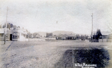 Sunbury & District Heritage Association Inc
Photograph
The post card is an early view of the intersection of Brook and Evans Street looking west and towards Sunbury Station. Mount Holden is in the distance. Chris Christianson's shop is on the LHS of the picture with the post office on the RHS. This image is an early view of Sunbury town centre with the railway station and post office. Like many country towns of this era, The roads have been formed but not surfaced. A sepia photograph in post card format of a view of a town centre showing an intersection and some small buildings with a hill in the distance.TO THE RAILWAY/SUNBURYbrook street, evans street, sunbury railway station, christianson, chris. -
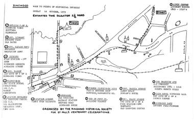 Ringwood and District Historical Society
Pamphlet, Ringwood Walk - Points of Historical Interest, 1979
Sketch of walking route for 17 historical points of interest organised by the Ringwood Historical Society for St. Paul's Church Centenary Celebrations - 14 October 1979, estimated duration 2-1/4hours.1 - Start 2 - Cnr Braeside Avenue, old township, brickworks 1881-1916, Guests, Herrys, Hills 3 - Club Hotel, Ringwood Hall, 1st site of C of E church corner 4 - Ringwood Lake, Anthony Ford - pioneer 5 - Opposite Bardia Street, Sandy Gully, Duncan's Hotel 6 - Opposite Pratt Street, 2nd site of C of E, 2nd fire station, Bentleys, old shopping centre 7 - Warrandyte Road, Former Clocktower site, Pratts butcher shop, Bamfords 8 - End of Pitt Street, building viaduct 9 - Bedford Road, Webdales, old crossing, railway station 10 - Station Street, views over railways 11 - Station entrance, old shopping centre, 2nd Postoffice, 2nd blacksmiths, Mechanics Institute, Town Hall 12 - Clocktower, 3rd State School, coolstores, 3rd Postoffice, market, Kenworthys 13 - Opposite market, 3rd site of C of E, Ringwood views 14 - Adelaide Street, Dickens, 1st fire station, Ringwood Reserve 15 - Opposite squash courts, Matlocks, Salvation Army 16 - Opposite library, bowling club, old baths 17 - Outside C of E, Ringwood views, Brittens, Glamorgan -
 Flagstaff Hill Maritime Museum and Village
Functional object - Luggage Trolly, Late 19th to first half of the 20th century
The subject item is an old style luggage or porters’ trolley used on railway stations throughout Australia. These types of porter trolley's served a vital role in supporting passengers to move their luggage around on a station platform. An everyday item used on stations platforms to move luggage around by a porter it is significant as it is an item not used now but can give us a historical view of social life and snapshot of Australia's main source of transport in the Victorian era the train.Luggage or cargo barrow without sides, made from iron wheel and wooden slats with metal supports.Noneflagstaff hill, warrnambool, shipwrecked-coast, flagstaff-hill, flagstaff-hill-maritime-museum, maritime-museum, shipwreck-coast, flagstaff-hill-maritime-village, wheelbarrow -
 Eltham District Historical Society Inc
Postcard - Photograph postcard, Panorama at Eltham, Vic, c.1923
The Rose Series P. 4284 post card Taken from near what would be present day CLC car park looking southwest across Diamond Street, present-day Andrew Park to the railway station and developing Eltham shopping precinct. Arthur Street visible, Pryor and Luck Street not evident. Sunnybrook, the Taylor home is visible at the top of the hill in Bible Street. Only three residences visible in Arthur Street on the southern side, two of these are the David Harbison Rest Home at 10 and 12 Arthur Street (built and opened in November 1919), present day site of Eltham Mall. There are none on the north side of the street. Based on 1945 aerial view there are 8 buildings on the northern side between Main Road and Bible Street which and given the extent of commercial development on Main Road, it is estimated this image is circa 1925. Luther Haley was the first to build an open a baker and General Store in this location next to the railway station in 1902. However, it took nearly twenty years until the early to mid-1920s when a period of significant growth in the Eltham shopping centre happened with many businesses relocating their operations from the original town centre of Maria Street in Little Eltham as well as new businesses opening. Other stores/buildings noted (L-R) are: Stationmaster's House built circa 1910 Eltham Hardware Store opposite the railway station first opened on Main Road opposite the Railway Station around late 1922. An advertisement placed in the Hurstbridge Advertiser advised that the Hardware Store had just opened with a varied stock of Saws, Hammers, Nails, Shovels, Screw Drivers, and every article required in a house or on a farm. People were also encouraged to try their Jams, Pickles, Sauces, Cups and Saucers, etc. Newsagency with 'Leader' advertising on awning - E. J. Andrew opened his newsagency shop opposite the station in March 1923, advertising for sale stationery, school requisites and periodicals. Bird Brothers Cash Grocer & Fruiterer opposite the railway station offering summer drinks and confectionery a specialty with a full Stock of groceries of the best quality always on hand at city prices opened December 1921 William Capewell's Butcher shop at the corner of Dudley Street. Capewell previously had a small shop in front of the station opposite Luck Street. He enlisted in the AIF during WW1 and returned home in 1919. He re-applied for a slaughtering license in February 1920 and was advertising by October 1922 supplying all districts. Not visible (or not yet identified) but in business by October 1922 were: J.H. Fraser, Carpenter and Builder at Luck Street opposite the station George A. Danslow, Hairdresser and Tobacconist opposite the railway station Miss Barber's 'Blue Gum' Soda Fountain opened October 1922 opposite the railway station (hidden behind Stationmaster's House). It was so named due to its proximity to a tall Blue Gum tree G.H. McDonald Boot Repairer opposite the railway station In December 1923 the first portion of the main street to be formed from Dudley to Arthur streets was almost completed. This is the section in front of Capewell's Butcher shop though it is difficult to fully make out from the photoDigital file only Postcards scanned from the collection of Michael Aitken on loan to EDHS, 2 Sep. 2022michael aitken collection, eltham, postcards, arthur street, david harbison rest home, electrine candles, eltham railway station, eltham shopping centre, lloyd's general store, red rattler, rose series postcard, rose stereograph company, tait train, velvet soap, andrew park, bible street, bird brothers cash grocer & fruiterer, bird brothers cash grocer and fruiterer, butcher, diamond street, dudley street, eltham hardware and timber, eltham hardware store, eltham mall, main road, station masters house, stationmaster's house, sunnybrook, w.j. capewell, w.j. capewell butcher shop -
 Eltham District Historical Society Inc
Negative - Photograph, Eltham, Vic, c.1890
View looking northeast from present day Ely Street (near intersection of present day Cronus Court and Porter Street) across what will become the site of Eltham High School towards Main Road showing the Eltham Courthouse and Police station. View is very similar to the sketch of Eltham published in 'The Illustrated Australasian News', December 26, 1884, p212. Note the large bluestone cell block behind police house and stable. George Knapman's Shoeing Forge next to the courthouse and the concentration of buildings around the Evelyn Hotel and Watson's Eltham Hotel on opposite sides of Main Road at Pitt street. Also note George Stebbing's cottage (c.1860) on Pitt Street behind the courthouse and 'Sunnyside' (home of W.J. Taylor built c.1885) at the top of the hill on Bible Street. In the foreground are orchards running up to the main street, Maria Street and also between Brougham Street and Dalton Street bordered by Bible Street.This photo forms part of a collection of photographs gathered by the Shire of Eltham for their centenary project book,"Pioneers and Painters: 100 years of the Shire of Eltham" by Alan Marshall (1971). The collection of over 500 images is held in partnership between Eltham District Historical Society and Yarra Plenty Regional Library (Eltham Library) and is now formally known as the 'The Shire of Eltham Pioneers Photograph Collection.' It is significant in being the first community sourced collection representing the places and people of the Shire's first one hundred years.Digital image 4 x 5 inch B&W Negshire of eltham pioneers photograph collection, eltham, 1890, bible street, brougham steet, dalton street, eltham courthouse, eltham hotel, evelyn hotel, franklin street, grant house, knapmans forge, main road, maria street, orchards, police residence, police station, pre 1900, stebbing cottage, sunnyside, w.b. andrew corn store, watsons hotel, little eltham -
 Eltham District Historical Society Inc
Photograph, George Coop, Mont Albert Railway Station, c.1956
Churchill Street shops just visible on right of image. The grass embankment visible in the distance on the left of the track is from where another view looking down the track beside Churchill Street was taken. Shows the original building on the northern platform of the Mont Albert station. The railway line was extended out to Lilydale with work commencing in 1882. Mont Albert station opened in 1890. It is presumed that this building was demolished when the third line was constructed in 1971. At the same time the nearby Surrey Hills original station buildings were demolished. George noted that he had donated a black and white print copy of this image some years earlier to the Surrey Hills Historical Society - see SHP2018/21/6 https://victoriancollections.net.au/items/5d6a450a21ea670e188d05c9Digital TIFF file Scan of Kopdak 620 black and white negative transparencygeorge coop collection, churchill street, mont albert railway station